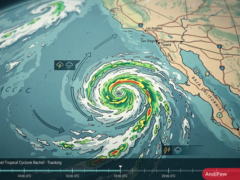
As Post-Tropical Cyclone Rachel shifts off the coast of the Baja California Peninsula and Southern California, coastal communities are on high alert. While the system has transitioned from a tropical storm into a post-tropical cyclone, it continues to deliver powerful ocean swells, dangerous rip currents, and bands of subtropical moisture northward.
From the rocky bluffs of San Diego County to low-lying harbor communities in Newport Beach and Long Beach, emergency management teams are actively deploying sandbags and clearing storm drains.
Here is everything you need to know about Post-Tropical Cyclone Rachel, the latest hurricane tracker insights, coastal hazard warnings, and safety precautions.
What Is Post-Tropical Cyclone Rachel?
A tropical system transitions into a post-tropical cyclone when it loses its classic warm-core tropical characteristics—often due to moving over cooler ocean waters and encountering atmospheric wind shear.
Even though meteorologists designate Storm Rachel as “post-tropical,” this classification change does not mean the hazard has passed. The storm remains an expansive low-pressure system capable of generating:
- Heavy ocean swells and destructive shore breaks.
- Coastal inundation during astronomical high tides.
- Localized heavy downpours and mountain thunderstorms fueled by subtropical humidity.
- Gale-force wind gusts across offshore shipping waters.
Tracking Storm Rachel: Path and Trajectory
Following updates from the National Hurricane Center (NHC) and the National Weather Service (NWS), Rachel’s track has shifted along the eastern Pacific corridor.
Anyone monitoring the hurricane rachel tracker will notice that while the core circulation center stays largely offshore or weakens over northern Baja California, the wind field and wave energy fan out over hundreds of miles.
Because the storm’s energy interacts with an incoming upper-level trough, the primary hazards for Southern California remain marine conditions and coastal surge rather than widespread hurricane-force inland winds.
Regional Impacts: San Diego News and Southern California Forecast
Local weather patterns across Southern California are shifting rapidly as the storm system progresses. Here is how specific regions are experiencing the impacts:
San Diego County
San Diego news reports confirm coastal protection crews have reinforced beachfront accessways from Imperial Beach up through Oceanside.
- Marine Hazards: Breakers reaching hazardous heights, producing life-threatening rip currents.
- Precipitation: Light to moderate rain bands, with higher rainfall totals concentrated over foothill and mountain regions.
- Humidity & Winds: Elevated dew points making temperatures feel unusually muggy, accompanied by gusty coastal breezes.
Orange County (Newport Beach, Huntington Beach, Seal Beach)
In places like the Balboa Peninsula in Newport Beach, municipal workers have constructed large sand berms.
- High Tides & Inundation: Astronomical high tides combining with southerly storm swells create risk for saltwater spilling over boardwalks and harbor bulkheads.
- Beach Erosion: Continuous pounding surf is cutting away sand dunes and narrowing recreational shorelines.
Los Angeles & Ventura Counties (Malibu, Long Beach, Catalina Island)
Long Beach, Zuma Beach, and Santa Catalina Island remain under active coastal flood advisories.
- South-facing beaches are especially prone to wave overwash.
- Harbor walkways, low-lying bike paths, and oceanfront parking lots face temporary closures during peak morning high tides.
Potential Impacts Comparison: Coast vs. Inland
| Metric | Coastal Areas (San Diego to LA) | Inland Valleys & Foothills | Mountain & Desert Areas |
| Primary Risk | High surf, coastal surge, erosion | Slick roadways, brief showers | Flash runoff, isolated lightning |
| Typical Rainfall | 0.10 to 0.50 inches | 0.25 to 0.75 inches | Up to 1.5 to 2.0 inches locally |
| Wind Exposure | 20–35 mph gusts (gale force offshore) | 15–25 mph gusts | 25–40 mph ridge gusts |
| Advisories | High Surf, Coastal Flood Advisory | Flood Watch (localized) | Flash Flood / Wind Alerts |
Safety Guidelines During Coastal Storm Events
When post-tropical systems deliver rough seas and erratic downpours, following basic safety measures helps prevent accidents and property loss:
- Avoid Rock Jetties and Piers: Sudden, rogue breaker waves can sweep unsuspecting spectators off breakwaters and seawalls.
- Heed Lifeguard Flags: Even experienced surfers face extreme hazards due to complex, multi-directional swell patterns and violent longshore currents.
- Prepare Sandbags for Low-Lying Homes: If your property borders a coastal canal, harbor, or low-elevation street, place sandbags around doors, garage thresholds, and drainage gates.
- Never Drive Through Flooded Roads: Standing seawater or pooled roadway runoff hides potholes and can easily stall vehicles or compromise braking systems.
- Clear Gutters and Downspouts: Remove dry brush and leaf debris so sudden downpours do not cause neighborhood street backing.
Frequently Asked Questions (FAQ)
What is the difference between a hurricane and a post-tropical cyclone?
A hurricane is a warm-core, organized tropical cyclone driven by heat released from tropical ocean waters. When the storm moves into cooler latitudes or encounters wind shear, it loses its symmetrical warm core but can still retain high wind speeds, heavy rain, and massive wave energy as a post-tropical cyclone.
Is Storm Rachel expected to make a direct landfall in California?
Post-tropical systems along the US West Coast rarely make a direct, intact hurricane landfall due to California’s cold offshore waters (the California Current). Instead, the circulation center typically weakens offshore or tracks across Baja California, sending outer moisture bands and high surf northward.
Where can I find real-time updates on Post-Tropical Cyclone Rachel?
You can monitor live data via the National Hurricane Center (NHC), local offices of the National Weather Service (San Diego and Los Angeles/Oxnard), and local emergency alerts broadcast across regional news outlets.
How long will the elevated surf and rain last in Southern California?
Swell energy and intermittent showers often linger for 48 to 72 hours following the storm’s closest approach, with conditions gradually calming as the low-pressure system disperses into the prevailing jet stream.
Post-Tropical Cyclone Rachel serves as an important reminder that late-season tropical activity in the Eastern Pacific can directly affect Southern California coastlines. While inland flooding risks remain localized, coastal surf, tidal overflow, and strong rip currents demand vigilance.
Stay ahead of severe weather: Bookmark your local National Weather Service portal, sign up for regional emergency text notifications, and check marine forecasts before planning any coastal travel or water activities.